 Inglés UdeA - Cabezote - WCV(JSR 286)
Acciones
Inglés UdeA - EnlaceInteres - JSR(286)
Acciones


Signpost
Acciones
Portal U de A
In Urabá, the sea encroaches on land by more than three meters annually
Acciones
In Urabá, the sea encroaches on land by more than three meters annually
By: Carlos Olimpo Restrepo S. Journalist at UdeA Communications Department
The average shoreline retreat on the beaches of Urabá, Antioquia, is three meters per year, and in some places, it has reached up to 15 meters. This is one of the main findings reported by UdeA researchers in partnership with DAGRAN (Antioquia Administrative Department of Disaster Risk Management) and other international institutions. It was announced in a digital publication that compiles lessons learned, conclusions, and recommendations regarding coastal erosion, a phenomenon that impacts ecosystems and puts infrastructure, housing, and tourism at risk.
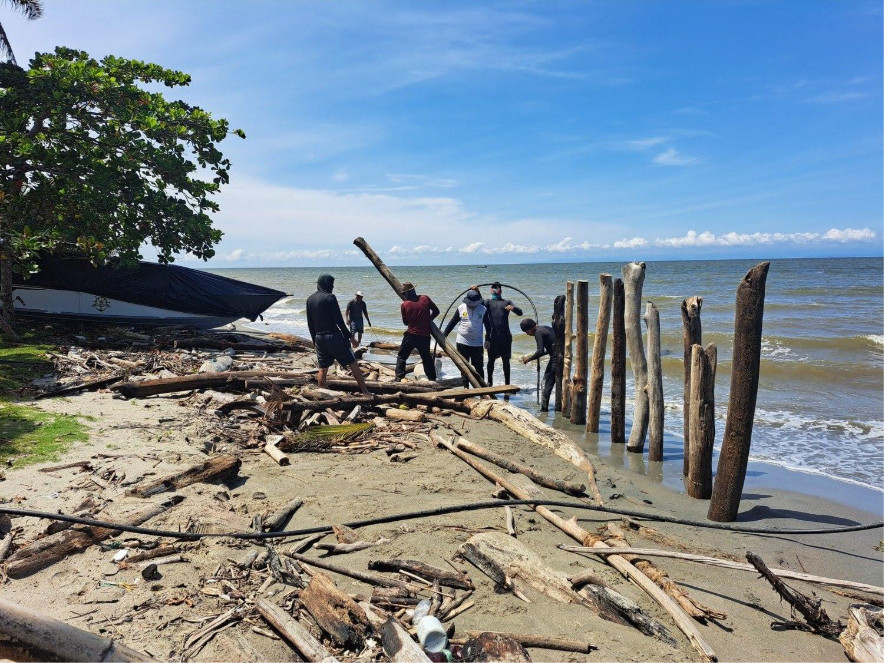 In Turbo and Necoclí, Pimecla program staff bury tree trunks that are washed ashore to reduce the impact of ocean waves on the coast. Photo: Courtesy of Pimecla
The coastline recedes on average about three meters per year in Urabá, Antioquia, and can retreat by up to 15 meters in the same period in some areas. This means that seawater is gradually advancing onto beaches and land, which seriously impacts ecosystems, while hindering some human activities and jeopardizing the region's tourism economy.
These are some highlights in a compilation of results from more than five years of research conducted as part of the Comprehensive Program for Monitoring and Mitigating Coastal Erosion (PIMECLA). Researchers from different disciplines at the Universidad de Antioquia, professionals from DAGRAN, and experts from foreign research centers have collaborated in this project.
The digital book, which compiles these and other conclusions, as well as a diagnosis of the coastal erosion problem in the Urabá region of Antioquia, was presented on July 15, 2025, at an event held at the Universidad de Antioquia Iván Darío Correa Arango Coastal Laboratory, located in the municipality of Arboletes.
"Coastlines are highly dynamic environments marked by significant morphological changes, which are noticeable on time scales of weeks. The Antioquia coastline is no exception. It presents primarily erosive conditions along approximately 62% of its length," stated the PIMECLA report.
"The phenomenon has multiple causes. There are natural causes, such as rising sea levels and increased wave energy, and anthropogenic causes—generated by human intervention or activities—such as poorly designed projects that protect a specific area but affect another," explained Vladimir Toro Valencia, a professor at UdeA’s Institute of Marine Sciences and technical leader of the PIMECLA program.
The professor, who is part of the Marine and Coastal Systems Research Group (GISMAC), added that beaches are the natural defense against wave energy, but for various reasons, less sediment is reaching the coast. Therefore, the shoreline's protective capacity is diminishing. "Beachfronts are becoming increasingly scarce, so waves are now impacting areas that are not prepared to absorb this impact," he warned.
Seeking a solution together
DAGRAN, under the leadership of UdeA researchers, traveled the 512 kilometers of the Antioquia coastline to identify critical areas of erosion, where the ocean advances on the continent, and accretion, where the continent gains space from the sea.
For this purpose, the PIMECLA program developed and implemented a monitoring plan that combined analysis of satellite and drone imagery, and measured the field to characterize the behavior of beaches and currents using equipment such as current meters and drift buoys.
Additionally, the CoastSnap project, a citizen science initiative, was implemented. It allows communities and visitors to monitor short stretches of the planet's coastlines by taking photographs from fixed points, which also enables the contribution of other scientific data.
One of the main results was a detailed map of rates of erosion and accretion—the shrinking or growing of the coastline—along the Antioquia coast. The CoastSnap project also yielded a new oceanographic database on variables such as waves, tides, currents, and sediments.
This work has been conducted mainly in the UdeA Iván Darío Correa Arango Coastal Laboratory in Arboletes. The laboratory, named after one of the pioneers of marine and coastal sciences in Colombia, is where PIMECLA scientists design and implement green solutions—a blend of traditional and nature-based solutions—to mitigate the problem of erosion.
Some of these green alternatives stem from the knowledge and practices of some communities, such as slope profiling, which involves cutting and stabilizing slopes exposed to the sea, revegetating them, and adding filters for subsurface water at the top and a row of stones at the bottom.
"The community had already been working on this in Arboletes. What we did was introduce technical concepts to improve the solution," explained researcher Vladimir Toro Valencia.
Another green solution is to use logs that wash up on the beaches, a technique used by the communities of Turbo and Necoclí. These logs were randomly buried in the sand to cushion the impact of the waves. "The communities taught us this technique. We put forward a specific layout using physics and coastal engineering criteria, and that's how we proposed a wave-shaped layout, which allows wave energy to dissipate in multiple directions," the professor added.
These green solutions are less expensive than traditional coastal structures, such as jetties or tombolos, and can be built and maintained with the communities. They offer more environmental benefits and are being designed with landscape criteria in mind. "Just because it's a less expensive solution doesn't mean it can't be aesthetically pleasing. We're working with a PhD student who is an architect/landscaper to properly integrate these constructions into the environment," Toro Valencia emphasized.
"We are from the coast as much as we are from the mountains, and people from Antioquia should be proud of this. At the Institute of Marine Sciences, we understand that Urabá is a region with tourism and economic potential, which must be developed responsibly," stated Vladimir Toro Valencia, technical leader of PIMECLA.
This program also trained members of Municipal Risk Management Councils in Urabá and strengthened environmental education in schools and coastal communities. The approach has been twofold: Scientists learn from local practices, and communities receive training and tools to monitor and manage their own territories.
Professionals from fields such as oceanography, coastal ecology, oceanographic and environmental engineering, territorial development, social sciences, architecture, and landscaping participated in the PIMECLA program. They were assisted by experts from Universidad Nacional Autónoma de México. "We have concluded that the problem of coastal erosion is so complex that it cannot be solved solely with traditional engineering practices. We must consider land use planning, risk management, and, above all, social participation," emphasized Vladimir Toro Valencia.
The challenge now is to maintain monitoring, as well as propose and design innovative alternatives that mitigate coastal erosion throughout the Urabá region of Antioquia and can be replicated along the Colombian Caribbean and Pacific coastlines. "The sea will always be dynamic, and we can't stop it, but we can learn to live with it more intelligently," stated the UdeA professor.
Portal U de A - Redes Sociales - WCV(JSR 286)
Acciones
Inglés UdeA - Iconos Footer - WCV(JSR 286)
Acciones